Peaks and Panoramas | Austria’s 275km hiking Trail


Will Robson heads off in search of adventure on a whistle-stop three-day trip exploring the 17-stage, 275km route in Austria’s largest national park. Cue waterfalls, lofty peaks and schnitzel aplenty along the Panorama Trail
Standing near the bottom of the Krimml Falls, in the Hohe Tauern National Park in Austria’s Salzburgerland, I’m being gently drenched by the hanging cloud of mineral-infused water vapour. It’s not unpleasant, but deep mist inhalation is clearly nirvanic for the nearby circle of neo-yogis sitting cross-legged beside the thundering water. My guide and National Park Ranger Martha Hutter tells me the falls have been used as a water-therapy treatment for allergies and asthma for over 200 years. It’s certainly the biggest steam room I’ve ever stood in.
The Krimmler Ache River flows from glaciers 20km up the Ache Valley, before dropping, in three steps, 380m down into the Salzach River and eventually into the Black Sea. It’s the highest waterfall in Austria and marks the beginning of the Panorama Trail, a 17-stage, 275km route east from Krimml to Hüttschlag, via Zell am See (well-known to Fall Line winter readers).
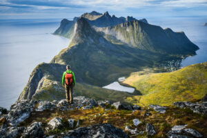
The trail lies within the Hohe Tauern, the largest national park in Austria (1,834km²), the largest nature reserve in the Alps and home to the highest mountain in Austria, the Grossglockner (3,798m). The region is not well-known to British summer travellers but initiatives like the Panorama Trail aim to remedy this.
The Panorama Trail opened during May 2022 with Fall Line the first UK media to visit the trail, albeit on a whistle-stop three-day trip in early September ’22, hiking the first two legs, then stage 12, one of the longest days on the Panorama.
Martha, here at the falls to set me off in the right direction, is eyeing my Innov-8 trainers and trail-running pack, but not, as I feared, to demand I wear solid hiking boots and an A-frame rucksack. She’s wearing trainers too and agrees it’s best to travel fast and light when possible, even on mountain trails.
Admittedly, I’m day hiking the Panorama Trail, with Austrian company Trail Angels moving my bag between overnight stops, so I need carry only snacks, water, wet weather and safety gear.
The Trail Angels info pack does nothing to undermine the stereotype of Austrian efficiency: 30+ pages of route, equipment and accommodation details, along with labels for my bag. I’ve also downloaded the Outdooractive app, giving me (mostly) step-by-step navigation along the route.
Martha encourages me to take the trail up the left-hand side of the Krimml Falls. This trail has Roman origins; the path up the right side, first built in 1879, is for tourists wishing to top the falls, stopping for pictures and ‘kaffee und kuchen’ on the way. No contest.
I find myself very much alone on the Roman side. Heavy rain has washed away loose soil, leaving a jagged highway of well-laid but hard-going rock slabs. I summon my inner legionary, hiking poles clacking rhythmically on the path as the sunshine breaks through the vertiginous pine canopy; the continuous roar of the falls envelops all. I try not to stare longingly at the restaurant on the opposite bank halfway up the tourist path.
After a climb of some 450 vertical metres up to 1,500m, the first day’s 11.4km route brings me back down again to the visitor centre of the falls. It seems churlish not to have some strudel before setting out on the rest of the hike, about 4kms north to Hochkrimml, climbing up to 1,650m.
The path leaves the tourist trail now and the new green rectangular Panorama Trail signs are few and far between. The high alpine pasture is impossibly green and lush, like a perfectly mown lawn draped over steep mountain undulations, and interspersed with well-worn but tidy wooden farmhouses, their long balconies bedecked with pink geraniums and their adjoining cowsheds wafting a pungent aroma.
An electric fence has me using the app map to detour from the trail, around an empty field, before heading up into the forest for a long zigzag hike up to Hochkrimml, resting on a handy bench to look across the valley at Krimml Falls: a series of white slashes in the deep green mountainside.
After a quiet night at the stylish Alpengasthof Filzstein, I head towards the Plattenkogel-Express chair lift in Hochkrimml, at the eastern end of the Zillertal ski area. Although slightly dispiriting to stomp up a grassy piste alongside a perfectly good ski lift, at the top is a restaurant and it’s open. Lederhosen-clad waiter Tim is delighted to see me, even if I can only manage a coffee. Strudel is too much, even for me, after a large hiker-appropriate breakfast at the Filzstein.
Summiting the Plattenkogel (2,039m), the sun is out and the views are outstanding. Below to the west is the Durlaßboden reservoir, while to the south is the Reichenspitze peak (3,303m) with a glacier so depleted it looks like the sad scrapings of an ice cream tub.
After two kilometres, the trail becomes a boulder-strewn alpine wilderness, known as the Leitenkammersteig. Wearing trainers requires more care in this uneven terrain but for some, it’s easy. I meet a local and her impressively fit dog who, she tells me, is a husky-cross who just gets stronger and faster as the day goes on. Don’t we all?

After a steep descent, including excusing my way through a large group of senior Austrian hikers not used to giving way to anyone, I enter the Leitenkammerklamm gorge, where more thundering water drops 300 vertical metres, twisting like ancient wisteria in a series of plunging waterfalls and swirling pools of jade-coloured glacial melt-water.
The day is one of the longest on the Panorama Trail at 19.5kms; the second half is an undramatic yet scenic skirt around the Durlaßboden reservoir before climbing up to the village of Königsleiten at 1,567m and well-earned schnitzel and beer.

My third day is tackling stage 12, billed as the hardest on the Panorama Trail: 25km of long ascent and even longer descent. From the Hotel Königsleiten Vital Alpin, I take a taxi to the village of Bruck, to meet my guide Karl Harbacek. It’s raining steadily as we set off on a 12km continuous climb to the mountain hut on the summit of the Hundstein (2,117m).
Karl is the embodiment of a mountain guide. His knowledge extends way beyond mountain safety into ecology, geology, and today especially: meteorology. He points out flowers such as the blue gentian, used in making a type of schnapps; and various fungi such as the deadly, red with white spots, Fliegenpilz; and the delicious Steinpilz.
At 2,117m, Hundstein is the highest of the Salzburg Slate Alps and the highest grass-topped peak in Europe, and while the climb isn’t technical, it’s long. As we leave the forest, the mountain levels into a plateau with meadows, ponds and sheep grazing. The weather eases for a while, but as we climb the long ridgeline to the summit, the rain whips in on a strong wind.

Managed as an overnight refuge for over 100 years, the Statzerhaus mountain hut looms out of the cloud and we pile in for lunch. The smell of meaty stew and fresh baking permeates the room as we hang up our ponchos and gently steam off, glad to be inside.
During our descent, the clouds part sporadically, and we glimpse amazing views of the Northern Limestone Alps to the north, and the Dachsteins to the south. We visit the Pfarrachhöhe, a mountain with three crosses on its summit and a challenging pilgrimage destination for the devout.

At the 20km point we pass the Reiser Aste managed hut, but sadly it manages to be closed so Karl and I wearily continue downwards to rendezvous with a taxi near Taxenbach, to my overnight stop at the Embacherhof Gasthaus. What a day – one hard to match for mountain-hiking experiences.
While only a taste of the 275km Panorama Trail, this has been more than enough to see the potential epic nature of hiking this lesser-known Austrian mountain region. The tourist honeypots of the Hohe Tauern quickly fall behind as you climb through the soft-floored pine forests into a glorious high alpine wilderness, with its distant euphonious cowbells, wheeling golden eagles and hard-won summits.
The Austrian Alpine Club classifies the Panorama Trail as ‘moderately difficult’; in other words, it’s perfect for the British hiker wanting somewhere challenging, but well within reach of schnitzel and beer at the end of the day.

The tourist board offers a Panorama Trail packages from June to September. Check up-to-date prices here. During summer 2023, trips cost €648 per person, including six overnight stays (breakfast and dinner) in a double room, five connected selected stages with luggage and shuttle transfer (not airport, see below).
Ryanair offers return flights from London Stanstead to Salzburg from £150 in July.
Salzburg to Krimml return taxi from €500 bookable via gasteintaxi.com
27th May 2025
30th May 2024


